
One down, one more to go. But at least we get a break on Tuesday. In fact, this is the brightest day we’ve seen in over a week! Sun should help get us well above the melting point in the afternoon, as we leap back into the 40s in most spots. Tuesday night, the colder air will settle in – just as the next storm rolling out of the Southern Plains takes aim at New England.
Wednesday morning’s commute should see a steel, gray overcast with a few flakes possible by mid-morning. Snow spreads out into the late morning and early afternoon in all areas, even on Cape Cod. This initial bump of snow will be significant in some cases, with road conditions and travel going downhill quickly.
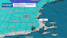
All told, a solid 3-5 inches is possible (with most spots on the low end of that range) and 1-3 along the coast.
Get Boston local news, weather forecasts, lifestyle and entertainment stories to your inbox. Sign up for NBC Boston’s newsletters.
While this burst of snow is significant, the warmer air will also rapidly infiltrate the area, switching us to rain through the night as temps rise. Gusty winds are expected across southeastern Massachusetts – specifically the Cape and Islands – with that mild air moving in late night and very early Thursday morning.
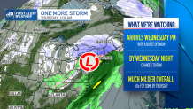
Most of the storm should be out of the picture by Thursday morning, but the warmth lingers. Highs should reach 50 in some spots, 40s in others as winds turn back to the west. We’ll turn briefly colder on Friday, with highs recovering to the 40s this weekend. The pattern should mellow out into early next week, but there could be more storminess ahead by midweek.
