What a difference a day makes.
Our recent warmth and beautiful stretch of weather seems like a distant memory. Coming off of record hot temperatures yesterday for some of us, we’re around 40 degrees cooler in spots and will be staying cooler than average for several days in a row.
It’s a part of a pattern shift, one that was ushered in with last night’s thunderstorms in dramatic fashion for some. In terms of wet weather today, scattered showers will redevelop, especially from early afternoon onward, expanding westward a bit this evening. Off and on showers, patchy drizzle and fog will be around tonight, with overnight lows in the 40s.
Get Boston local news, weather forecasts, lifestyle and entertainment stories to your inbox. Sign up for NBC Boston’s newsletters.
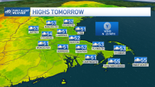
Tomorrow will feature little change; morning showers at the coast will back westward during the midday to afternoon, continuing off and on through the evening. Highs will be in the 50s once again. The wind is also worth mentioning, as it will gust to 35 mph, though on Cape Cod, gust to 40 mph (isolated 50mph) will make it feel even colder.
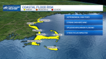
Combine this with astronomical high tides and our seas will build, resulting in 5-10 foot waves, localized beach erosion, rough surf and multiple high tide cycles of splashover and minor coastal flooding.
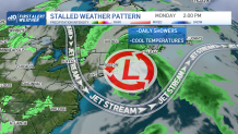
Next week doesn’t feature much improvement. A big upper level low will stall out and keep periodic showers and cooler than normal temperatures around for days. I’m hopeful that we can kick the storm out here and bring brighter skies and warmer air back just in time for next weekend.