
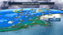
High pressure is the main feature on the weather map Monday, and will provide us with dry and pleasant weather by December standards.
Clouds will be on the increase later on Monday afternoon, but despite that, our highs will top out in the 40s pretty much regionwide. A fresh breeze out of the southwest will gust occasionally to 20 mph.
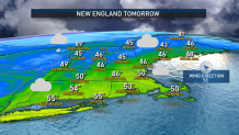
Overnight, clouds will thicken up ahead of some showers and rain for some of us Tuesday. The wet weather will primarily be confined to central and western New England, with scattered showers turning to pockets of rain through the day. Aside from an isolated shower or two, much of eastern New England will stay dry. Expect highs in the 50s, more than 10 degrees above average for this time of year.
Get Boston local news, weather forecasts, lifestyle and entertainment stories to your inbox. Sign up for NBC Boston’s newsletters.
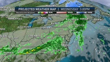
Wednesday turns wet for all, as a cold front to our west nudges closer. It’s certainly a raincoat or umbrella day with areas of rain anticipated from the morning right on through the evening commute. For most, this will add up to half an inch to three quarters of an inch. Highs will once again be in the 50s.
Beside the front on Thursday, we dry out with some limited sunshine before the next disturbance approaches. There is still some uncertainty as to how this next system impacts us; a range of solutions from a few showers on Friday to more steady rain on Saturday or little if any precipitation is still on the table. We may stay unsettled through the middle part of next week. We’ll keep you posted in the days to come.
Otherwise, expect cooler air to return on Friday and stick around through the remainder of our exclusive 10 day forecast with highs generally in the upper 30s to low 40s.
