
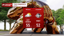
We’re on the final leg of the rain from this weather system. A few lingering downpours are possible before drier air sweeps in above and shuts off the water. The timing couldn’t be better for the unveiling of The Embrace on Boston Common early Friday afternoon. Expect temps in the mid-50s with some spokes of sun possible from time to time.
We’ll be fortunate enough to bask in the mild air throughout the late afternoon as well. This gives us ample time to dry out the roads and landscape before we see the colder air shuffle in early Saturday. Gusty winds will slowly back down as well. We’ll still be looking at a steady wind all day, but the worst is passing early this morning.
Get Boston local news, weather forecasts, lifestyle and entertainment stories to your inbox. Sign up for NBC Boston’s newsletters.
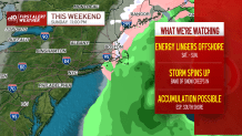
The weekend sees cold temps, and what once looked quiet and bright is now a bit more cloudy with a possibility of some snow. A large storm is brewing offshore and a finger of snow on the extreme northwestern side of the storm could latch onto eastern Massachusetts early Sunday morning. The temperatures are marginally cold, but giving a perfect setup (a rarity so far this winter) we could see some accumulation. The storm will eventually drift away by Sunday night.
Chilly temps for MLK Day on Monday, then a gradual warming ahead of more rain. As long as the storms keep rolling into California, we’re spared any arctic outbreaks. That could change after Jan. 20, as a wholesale pattern shift comes to North America. Stay tuned!
Weather

Enjoy the long weekend and be safe!
