As Friday’s storm center intensifies and moves up the Eastern Seaboard en route to a passage over southeastern Massachusetts overnight Friday night, a conveyer belt of moisture continues to feed off the Atlantic.
Encountering air that was marginally cold for snow, an easterly wind gusting to over 50 mph along the coast has succeeded in carrying milder, marine air into eastern and coastal New England for rain, rather than snow.
Further inland, just enough cold air holds on for heavy, wet, pasting snow. The delineation has set up from around Rochester, New Hampshire, southwest to Gardner, Massachusetts, and Northampton to the southwest corner of the Commonwealth, and near this transition zone we’ve seen an oscillating combination of sloppy snow and rain.
Get Boston local news, weather forecasts, lifestyle and entertainment stories to your inbox. Sign up for NBC Boston’s newsletters.
Further northwest, the weight of the accumulating snow will pressure power lines, resulting in power outages, especially where a gusty wind contributes to the load on the lines, leaving the Eastern Slopes of the Berkshires to much of Vermont, central and northern New Hampshire and interior Maine, particularly north of the Maine Turnpike, especially vulnerable.

Further south and east, rain, heavy at times, will impact the second commute of the day in the late day and evening with periodic downpours resulting in large puddles and ponding of water with road spray. That'll reduce visibility and all of it will contribute to slow and slippery travel, with rain totals around two inches expected. That's actually beneficial for portions of northeast Massachusetts, still in severe drought. Rain and snow will continue into the overnight Friday night, with predawn Saturday bringing a southward sagging rain/snow line to change even the Massachusetts Turnpike corridor to brief snow from predawn Saturday until around mid-morning. That will end from west to east after dropping a coating to an inch of snow in much of the northeast quarter of the Bay State into extreme southeast New Hampshire.
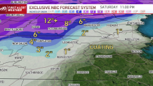
Sun emerges Saturday midday and afternoon with a cool northwest breeze as some New Englanders dig out, while others simply brush off or only dry out. All of New England will enter a fair and cool stretch of weather from Saturday afternoon through midweek next week, before the next storm takes shape and once again holds potential to be a coastal storm of either snow or rain.
This storm is one our First Alert Team shared the potential of on Monday, so the signals have been very consistent from very far out, and the likelihood of a storm developing remains high. What’s yet to be determined, of course, is storm track, exact intensity and, therefore, impacts from rain and snow. At this point, we know there’s a lot of energy involved so the potential for a powerful storm is there for Thursday night into Friday, Dec. 23. We’ll keep you posted on how it shakes out.