
You can find an updated list of school closings and delays here.
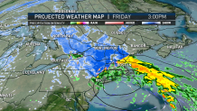
New England’s first winter storm of the season has arrived. The forecast remains largely unchanged. The system starts out warm across southern New England as heavy rain pours in throughout Friday. Between Cape Ann and Cape Cod, wind advisories have been issued for strong gusts beyond 45 mph throughout the day. And some schools have already decided to close for the day.
WATCH: Live weather coverage from NBC10 Boston all day Friday on Roku and Peacock.
Get Boston local news, weather forecasts, lifestyle and entertainment stories to your inbox. Sign up for NBC Boston’s newsletters.
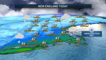
The wind, coupled with downpours of rain, will likely reduce visibility across the Boston Metro throughout the day. Rainfall rates will be between 0.15 to 0.25 inches per hour, resulting in areas of flooding on roadways. Some of the highest rainfall rates will start near central Bristol County around 10 a.m. and push toward the coast. Heavier rain spreads across the Boston Metro to the north shore around 1 p.m. Warmer air surges in with the rain and temperatures respond by climbing into the upper 40s, near 50s by Friday evening.
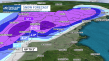
Not too far away, the air will be far cooler across central Massachusetts, the Worcester Hills, the Route 2 Corridor and Merrimack Valley. As cold air establishes itself, so does the snow. Because of the milder air & moisture in the atmosphere, snowfall will likely be wet and heavy, versus fluffy and dry with significantly cooler temperatures. That said, totals will stack up to nearly 4 inches in north central Worcester County, with 6 inches along the Massachusetts-New Hampshire state line. Winter weather advisories have been issued for that portion of the county until Saturday morning. Weather storm warnings are up for all of Vermont and western Massachusetts.
Plan on slushy and slippery road conditions for much of Friday and lasting through Saturday morning. Specifically, along I-495 in Littleton and Route 2. The graduation for snow accumulation will be steep, as just north of Massachusetts, southern Vermont and New Hampshire prepare for nearly 10 inches of snow. Snow totals will be substantially higher to the north across higher terrain in the Berkshires and Greens, where a foot to nearly two feet of snow is possible. Northwestern Connecticut and Litchfield County will see heavy snow too.
With the combination of winds and heavy snow, power outages are likely across New England. Representatives with National Grid have said the company is preparing and pre-staging crews across Massachusetts.
Shoveling snow may not seem difficult, but it can trigger heart attacks. The moisture content in this snow will be higher, and the result makes the snow more difficult to shovel. Shoveling this type of heavy, wet-snow can lead to overexcretion, and ultimately heart failure.
In the Boston Metro, as winds begin to turn directions with a northerly component, colder air will take over early Saturday morning. As the atmosphere cools, a brief window of opportunity for snow inside of the I-495 corridor will arise between 6 a.m. and 11 a.m. Saturday. While totals will be on the low end, the risk for car crashes will remain high. While a hard freeze isn’t expected, temperatures late Saturday night will drop to, or just below, freezing. Bridges, overpasses and well-shaded roads have the potential for slick and icy conditions pre-dawn, Sunday. Commute with caution.
Beyond this weekend, the NBC10 Boston First Alert weather team is watching an Arctic airmass setup for much of the Lower 48. While there are still details to be ironed out, the pattern would support a much larger storm impacting the region for late next week. A lot of the signals are there for another chance at accumulating, that would bring a White Christmas to New England.
Get updates on what's happening in Boston to your inbox. Sign up for our News Headlines newsletter.
