
Warmth has arrived to New England. Whether this mild air is a spring preview or autumn redux is up for debate. But, certainly the idea of a January thaw has been elevated in recent winters, with temperatures into the 50s and 60s something that – at least for a few stretches each winter – has almost become expected in New England, and this winter delivers again.
Expected doesn’t always mean welcomed – winter sports enthusiasts will see snow amount and quality drop dramatically in the seven day stretch ending next Thursday. While our New England sky is still in the transition process from cool to mild, waves of clouds continue to stream overhead, variable in their coverage and thickness and looking like rain at times Friday, but not actually delivering any until Saturday.
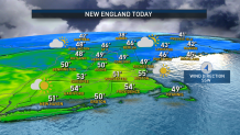
With variable clouds continuing overnight Friday night and a southwest breeze gusting up to 25 mph on Cape Cod, temperatures will remain above the melting point for just about all of New England Friday night, setting Saturday up for another run into the 50s even with nearly total cloud cover.
Get Boston local news, weather forecasts, lifestyle and entertainment stories to your inbox. Sign up for NBC Boston’s newsletters.
Most communities will salvage the first half of the day without much rain, but scattered showers start popping by midday, then continue to develop and expand, generally from southwest to northeast, Saturday afternoon, so that most of New England will be raining by Saturday evening and nearly all communities will either be wet or raining at midnight to ring in the New Year.
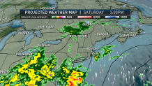
The storm center responsible for this rain crosses through southern Canada Saturday night, and with New England so far removed from the storm, our rain amounts will be limited to generally less than half an inch by the time rain ends Sunday early morning, leaving only a leftover isolated shower through mid-morning and emerging sun for midday and afternoon with a busy breeze from the west and northwest.
While northern New England finds lingering rain showers deeper into the late morning and midday that may end as scattered mountain snow showers during Sunday afternoon, central and southern New England make another run near and over 50 degrees, including at Gillette Stadium for the Patriots game against the Dolphins. The westerly wind, though, at 10 to 20 mph may make it feel slightly cooler as the air streaming in truly is, at least slightly, cooler by nature than Saturday’s mild and moist air.
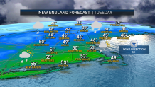
Regardless, variable clouds are back in the forecast Monday with highs near 50 degrees but, yet again, milder and moist air returning to New England with thickening clouds and showers expected Tuesday, showers with high temperatures for some surpassing 60 degrees Wednesday and a steady, incremental return toward normalcy by next weekend, at the end of our exclusive First Alert 10-day forecast.
