
Back to work, back to school and back to the tug-of-war between fall and winter. We’re bracing for a week of tumultuous temperatures.
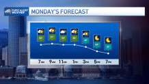
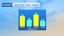
Sunday night’s rain brought in the milder air overnight. After hitting a daytime high of 54 around 11:45 am Sunday, the temperature leveled off in the evening, then spiked to 55 right before midnight. We’re still in that mild air Monday morning, but cooler air will slide in during the afternoon to bring us back to Earth by evening.
That cold deepens Tuesday – but still remains tolerable. Then we gear up for strong winds and more mild air for Wednesday (before stumbling through the 40s to end the work week).
Get Boston local news, weather forecasts, lifestyle and entertainment stories to your inbox. Sign up for NBC Boston’s newsletters.
Wednesday’s wild wind will be the event of the week. With stiff winds in the middle atmosphere zipping by at over 70 mph, we could see our winds top 40 mph along the coast late in the day/evening. While showers will move in late day ahead of the wind, some downpours are possible overnight as the weather system sends a strong cold front through the region.
Cold on the backside will race in toward Thursday morning, keeping the wind going (from a different direction) and preventing us from getting out of the 40s. Ditto for Friday.
Long, long range, the details are fuzzy (that’s nothing new). We’re seeing signs there may be cold by the end of NEXT week, but the questions remain. Is it really THAT cold and will it be transitory like this week’s cold shots or much longer lasting like with a pattern change?
Weather

The suspense builds. Have a great week.
