
The holiday weekend got off to a mild start yesterday, with many locations topping 50 degrees. While the clouds got the upper hand, we’re seeing fewer them around today.
What’s more is that some of that mild air will linger into the day today, providing us with another opportunity to hit 50 or better.
It all comes to a screeching halt tonight as an arctic front swings through New England. Some parts of Western or Northern New England will see snow squalls as the front passes, but very few flakes will make it to Eastern Mass/NH around midnight.
Get Boston local news, weather forecasts, lifestyle and entertainment stories to your inbox. Sign up for NBC Boston’s newsletters.
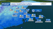
That won’t stop the cold air from charging in, however. Highs tumble back to the upper 30s tomorrow as winter winds return for a day.
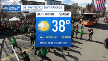
While temps struggle, wind chills hold in the 20s for the entire afternoon. This may put the Southie parade on ice, but at least the Sun will be out. We’ll see those winds back off at night, as we settle for ground-hardening teens and 20s into Monday morning.
Since this cold is short-lived, highs are expected to bounce back on both Monday (the first day of spring) and Tuesday, even surpassing some of the warmth we saw yesterday.
Next threat for any stormy weather is late next week, as more storms from the Left Coast traverse the country.

Have a great weekend!
