
What a weekend! Clouds depart and we enjoy sunny skies.
Our temperatures Saturday afternoon remain mild — we’ve climbed to the upper 40s since early in the morning and we’ve made it to the lower 50s in the warmest towns.
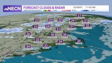
A cold front flows in Sunday and promises colder temperatures. The St. Patrick’s Day Parade will step off with highs in the 30s, brew-zy conditions, shivering shamrocks with chills in the 20s and a charming night with a few clouds around.
While there won’t be any rainbows, we’ll enjoy golden skies for the early morning hours before more clouds fill in on the second half of Sunday afternoon.
Get Boston local news, weather forecasts, lifestyle and entertainment stories to your inbox. Sign up for NBC Boston’s newsletters.
Thankfully, the winter vibes will only visit for a day.
Mother Nature is kind with us as we begin spring on Monday; highs will reach the upper 40s to near 50 and the first half of the week ahead will overall delight us with quiet weather.
The wind could be someone of nuisance for some, since the temperatures will feel slightly cooler and the gusts near 30 mph.
Tuesday will remain mild, with highs near 50 and Wednesday will allow for another mild start with variable clouds and the entrance for more moisture. This is when the passage of a new system will offer some showers late Wednesday into Thursday, and another round of mountain snow Saturday with mostly rain for southern New England as of now.
Stay tuned, your First Alert Weather Team will keep you posted.
