
Continual energy from a stubborn, upper-level low keeps cloudy conditions around New England throughout Friday and some of the weekend.
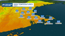
Friday’s rain will be the brunt of things with thunderstorms in the afternoon and evening, aided by energy from the sun. Rainfall amounts are generally less than a quarter of an inch, but embedded in thunderstorms, we’ll find higher totals approaching half an inch — specifically across Worcester, Bristol County, western Plymouth County and the Cape. By the day’s end, the showers begin to conclude.
Slowly but surely, clouds will break apart throughout Saturday, and temperatures climb into the lower-to-mid 70s. Sunnier skies await us on Sunday as warmer air moves in. Much of the region will see high temperatures in the 80s, under dry skies.
Get Boston local news, weather forecasts, lifestyle and entertainment stories to your inbox. Sign up for NBC Boston’s newsletters.
The reprieve from the rain won’t last long. We’re tracking another system early next week. Its genesis will bring severe weather across the Ark-La-Tex and I-20 corridor. While the DNA of the storm should shift, it will warrant watching early next week.
