
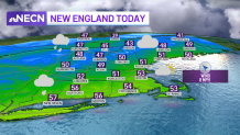
It’ll be a relatively mild December day despite overcast skies across the region. Our highs will top out over 50 in many locations, and in the 40s in far northern New England, about 5 to 10 degrees above average for the date.
Scattered showers will march into western and central New England from midday through the afternoon, so it’s worth having the umbrella in these locations. Much of eastern New England will stay dry aside from an isolated shower or two, mainly north and west of Boston.
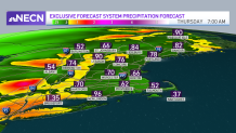
Tuesday evening, the showers turn to a steadier shield of light rain, and will impact us late during the evening, overnight and into Wednesday. It’s certainly a wet weather gear day with areas of rain anticipated from the morning commute, tapering to showers by the afternoon and evening, wrapping up generally 3 to 6 p.m. from western to eastern New England, respectively.
For most, the rain will add up to half an inch to three quarters of an inch, though a few locally higher amounts will be possible in western areas. Highs will once again be in the 50s Wednesday. Beside the front on Thursday, the sun returns and temperatures will generally run in the 40s to low 50s.
Get Boston local news, weather forecasts, lifestyle and entertainment stories to your inbox. Sign up for NBC Boston’s newsletters.
After that, our weather pattern turns unsettled and colder. A block in the atmosphere develops, keeping us wedged between big high pressure to our north, several mid level disturbances overhead and an ocean storm that will stay out to sea.
So what does that mean for us?
Overcast or mostly cloudy skies will be the norm from the weekend through the middle part of next week, with the chance of rain and some inland snowflakes mixed in across southeastern New England with a gusty onshore flow.
There are many details to iron out in the days to come, but no significant accumulation is expected. Otherwise, we stay at or below average temperature wise until a brief shot of mild air comes in on Thursday of next week as seen in our exclusive 10 day forecast.
