
The pattern rolls on, and so do the fires. As long as they continue to burn, we’ll be dodging smoke plumes and experience hazy skies across New England.
So far, over 9 million acres of forest biomass have burned throughout the Canadian provinces this year, 17 times the 20-year normal. In Saskatchewan alone, emissions totaled 23 megatons just in the month of May, obliterating the record of 2 megatons.
We’ll see the smoke thin out Wednesday, thanks to a small break in the massive plume. Locations just to the west will have thicker smoke, while areas to the north will see less. We’ll likely see the smoke return late week or into the weekend.
Get Boston local news, weather forecasts, lifestyle and entertainment stories to your inbox. Sign up for NBC Boston’s newsletters.
The rest of our forecast revolves around the presence of a stalled storm in Nova Scotia and New Brunswick. Showers rotating around this low will pester us with a daily risk of a passing shower (or three) throughout the remainder of the week.

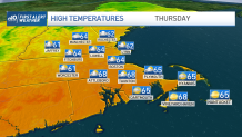
While no one spot is more vulnerable to wet weather than others, we will all eventually be tagged by some amount of rain. Cooler temps are in the offing too. Thanks to thicker cloud cover, we will only manage mid 60s in the coming days. Starting Thursday, sea breezes will cool us off even more in the afternoon along the coast. Ironically, this may also help stabilize the atmosphere, keeping the coast drier than other spots on Thursday and Friday.
