
We’re finishing the month of December and the year off on a cloudy and damp note. This work week has certainly seen its share of low impact systems from the get-go, so why wouldn’t we finish it off like that?
Overall, the threat for showers will be in the forecast right through Friday, New Year's Eve, with a more impactful storm arriving late Friday night. Sorry, snow lovers, we’re going to be on the warm side of this one as well.
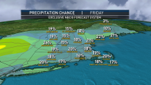
Another weak wave moves through overnight Thursday into Friday, bringing more showers south and snow/rain showers north before exiting Friday morning, but most of the day will remain cloudy and cool.
Get Boston local news, weather forecasts, lifestyle and entertainment stories to your inbox. Sign up for NBC Boston’s newsletters.
During the afternoon Friday, the sun may break out for a bit across Connecticut, allowing temperatures to reach 50 degrees! The rest of southern New England will remain in the mid to upper 40s, with lots of clouds and the risk for a shower or sprinkle. Northern areas will see a few rain/snow showers passing through with temps in the upper 30s to low 40s.
Clouds will increase and thicken New Years Eve night with the slight risk for a sprinkle/shower, but shouldn’t impact any outdoor plans as we ring in the New Year. Temps will be in the upper 30s to low 40s south, 30s north.
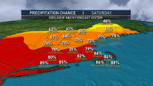
On New Year’s Day, a stronger system will arrive with widespread rain to the region along with milder temperatures. Some snow and mixed precipitation at the onset is possible across northern areas, but that will short lived.
It remains mild and rainy right through Sunday morning, then we’ll be tracking a strong cold front that will push through the region during the day. Some of the leftover precipitation may change to snow as the front ushers in much colder air.
Local
In-depth news coverage of the Greater Boston Area.

We’re also watching to see if low pressure develops along the frontal system late Sunday. If this happens, we could see a period of accumulating snow in southern New England Sunday night. It’s a low probability in terms of forecasting, but it is definitely something we need to watch. Stay tuned!
