Nothing better than summer weather… before summer. While it officially starts next Tuesday, it’s obviously been around here for a while.
That makes today’s forecast even sweeter: plenty of sun, low humidity and highs near 80. As breezes collapse near the coast, we may see a slight sea breeze kick in, but it’s cooling effect will be somewhat limited by all the warm sunshine (and air) milling about.
It’s around this time of year that the sea breezes lose much of their bite, unless they’re accompanied by a much cooler airmass. Which is almost where we are tomorrow. We cool just a bit, and the wind becomes less of a sea breeze and more of a true wind from the east/northeast. There is a distinct difference here.

Get Boston local news, weather forecasts, lifestyle and entertainment stories to your inbox. Sign up for NBC Boston’s newsletters.
The sea breeze is a localized wind that is born from the temperature difference between land and sea. The east/northeast wind (around high pressure) is played out on a much larger scale, traveling over the chilly, deep waters of the Gulf of Maine. The difference will be felt in the high temps. We’ll fall to the 70s tomorrow – low 70s at the water’s edge.
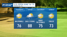
The turn comes on Thursday as the winds shift to the south. We’ll warm back up and see an increase in the humidity (along with a passing sprinkle). The steam heat moves in for a one-day stand on Friday.
We’ll get some early storms, then a possible late day storm – rest of the day is bright and hot. Highs soar into the upper 80s before cooling this weekend. Not a half-bad stretch for the U.S. Open… or anyone who’s enjoying the first week of summer vacation.


