
We have a First Alert for Friday due to heavy snowfall across much of New England. No damaging wind, no coastal flooding, just heavy snow that will make travel difficult, especially in the morning.
When is the snow coming?
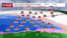
Snow showers head in from southwest to northeast overnight, with the snow beginning in Boston between 2 a.m. and 4 a.m.
Get Boston local news, weather forecasts, lifestyle and entertainment stories to your inbox. Sign up for NBC Boston’s newsletters.
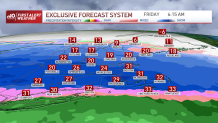
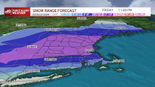
The heaviest snowfall is going to be 5 a.m. to noon. Snowfall rates of 1"-2" per hour are likely during the Friday morning rush into work. We see mainly snow in Boston and along the Mass Pike, until late morning.
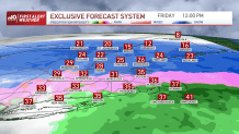
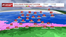
A nose of warmer air starts to head in from the south and will help to change over the snow to a wintry mix or sleet. Even areas along the south coast, Cape and islands may switch to rain for a short time in the afternoon. This will cut down on snow totals. Meanwhile, it is all snow across northern New England all day long. An easterly wind will also eat away at some of the snow potential around the immediate coast of the north shore, south shore and in Boston.
Weather Stories


The heavy snow tapers in the afternoon, but a few showers linger through evening. Ocean-effect snow showers linger on the south shore, Cape & islands into Saturday morning, bringing another 1" of snow overnight. Watch for temperatures to crash by Friday evening, leading to widespread refreezing and an icy Saturday morning.
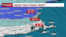
How much snow are we getting?
At the coast in Boston, north shore, south shore, Hartford, Providence, to the Maine coast, northern New Hampshire and Vermont could all see 4-7." The Merrimack Valley, along the Pike, southern Vermont, southern New Hampshire, southern Maine, western Massachusetts can all expect 8-12" of snow. Cape Cod, inland southern Rhode Island and Connecticut are looking at 4-7" of sloppy snow and sleet. 2-4" of snow then changing to rain on the islands, south coast of Massachusetts, Rhode Island and Connecticut. North of the Mass Pike we expect fluffier snow consistency, versus in Boston and south where we will see the wetter snow consistency which also contributes to lower snow totals.
10-day outlook
We have a break in any storms this weekend with lots of sunshine both days and highs in the 30s. Sunday there is a clipper system that will bring in a few snow squalls across Vermont, New Hampshire and Maine. After that moves through, all of New England will experience wind and colder temperatures into Monday as highs stay in the 20s.
A couple minor systems move through next week, one Tuesday night and another Wednesday night, that will give us some quick chances at snow. Temperatures stay in the 30s or 40s through the workweek.
Get updates on what's happening in Boston to your inbox. Sign up for our News Headlines newsletter.
