There’s a whole lot to love in the forecast today. Plenty of dry air, some sun and a refreshing breeze off the water.
Granted, we’re not in the low 80s like in the past two days, but we’re not sweating it out with soupy air and the threat for storms, either. Our breezes will be from the southeast, so 70s will have to do today.
Lots of uncertainty in the immediate time frame. We have storms firing tomorrow afternoon and evening. Some of these will undoubtedly have torrential rain and the threat for wind gusts that could cause trees and power lines to come down.

Get Boston local news, weather forecasts, lifestyle and entertainment stories to your inbox. Sign up for NBC Boston’s newsletters.
The question (in many of these severe weather setups) is how far the storms will progress to the coast.
We know western and central Massachusetts are under the gun for strong storms, but by the time they get to MetroWest or the Merrimack Valley, the storms will be far out ahead of the front (think mothership) that set them off.
As a result, they could run out of steam. In fact, some of our guidance doesn’t even have the storms making it to central Massachusetts. That’s our first item on shaky ground.

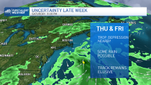
Next up is a developing tropical depression off the Eastern Seaboard late week. Most indications are that it will stay offshore, but it could stir up some wet weather with the aforementioned front on Thursday and Friday.
Weather Stories
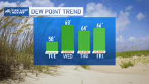
We’ll stay in the sticky air through the end of the week, so there’s not much change in that respect. It’s simply a matter of how much rain may come into the picture through Friday night.
File that under: unsettled finish to work week (with a few question marks).


