
Thursday certainly felt and looked like winter across much of New England with a widespread snowfall on the ground and cold temperatures!
With that being said, that’s the last of the snow for much of the area, as winter will be going on a small vacation starting this weekend and lasting right into next week.
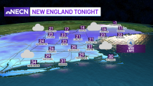
Clouds will increase and thicken Thursday night ahead of a weak warm front which will touch off some snow showers as it pushes northward. The higher elevations of western, central and northern New England could see a coating to an inch or so, but we're not expecting much more than that.
Overnight, temperatures will be cold south, in the 20s away from the coast and around 30 along the coast, with temperatures rising a bit late overnight. Lows will be mostly in the teens and low 20s north.
Get Boston local news, weather forecasts, lifestyle and entertainment stories to your inbox. Sign up for NBC Boston’s newsletters.
Friday will be somewhat unsettled, but noticeably milder, with some broken clouds across southern New England. Overall, not too bad of a day, however, northern areas will remain chilly and cloudy as the warm front slowly tries to push northward but gets stuck before reaching the Canadian border.
A few flurries and snow showers will linger into Friday afternoon across the higher elevations, especially of Maine -- closer to the coast in Maine, rain will mix in.
Weather Stories


High temperatures on Friday will range from the upper 30s to mid 40s across much of southern New England, near 50 along the south coast. Highs will be mostly in the 30s north, close to freezing along the New Hampshire and Vermont Canadian border and in the 20s northern Maine.
Low pressure, currently over the Great Lakes, will track to the north of New England Saturday and Saturday night, bringing with it widespread rain showers and wind along with very mild temperatures.
Rain showers will develop Saturday morning and continue into the afternoon. Some sleet and snow will mix in with the rain over central and northern New England, but that will be short lived as very mild air surges into the region via a southerly air flow.
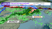
Highs will top off in the low 60s south, 40s and 50s north.
During the evening, wind out of the south will crank up, especially across southeastern New England as a strong cold front approaches from the west. We could see gusts over 40 mph, perhaps 50 during the evening and early night Saturday -- something our First Alert Weather Team will watch closely as new model information comes in.
Temperatures cool off a bit Sunday, but it won't be nearly as cold as we could be this time of year. Beyond that, next week is looking very mild.
