We have a fantastic day of weather on the way for the six state region of New England.
Despite the cooler start out there, our temperatures will rebound quickly, climbing into the 60s north and 70s south, with less wind than yesterday and plenty of sunshine, too.
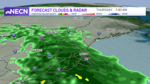
Some clouds will advance in from west to east this evening ahead of a warm front that will approach tomorrow. Expect some rain to break out during the overnight into pre-dawn Thursday, and continue as a steady rain for many Thursday morning to midday.
Get Boston local news, weather forecasts, lifestyle and entertainment stories to your inbox. Sign up for NBC Boston’s newsletters.
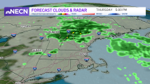
After that, we’ll stay cloudy but mainly dry for the remainder of the day in southern New England, and see a renewed area of showers develop from west to east in central and northern New England during the afternoon to evening. So it’s worth having the wet weather gear with you on Thursday and plan on budgeting a little extra time for the morning commute too.
By Friday, we’re on the warmer side of the front, and temperatures will climb well into the 70s and even some lower 80s.
We really crank up the thermometer this weekend; highs will soar into the upper 80s and lower 90s, challenging records in many communities. Combined with the humidity, it’ll be a full fledge summer feel, so plan on taking it easy.
Get updates on what's happening in Boston to your inbox. Sign up for our News Headlines newsletter.

Both weekend days will also feature the threat for thunderstorms, though more scattered action is anticipated on Sunday (hit or miss stuff Saturday) – so if you have outdoor plans, make sure to have a backup plan to seek shelter indoor should you need to.
Behind that weather boundary, we’ll be about 20 degrees cooler (around 70) on Monday. Highs next week will be more “normal” – running 65 to 70 most days with a few showers possible, especially on Wednesday as seen in our exclusive 10 day forecast.