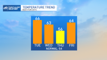
The first few days of November were chilly and dry… up until yesterday. The high temperature of 60 was a solid 6 degrees above normal. Today we build on that warm spell, pushing the high temperatures to 13-14 degrees above normal. (If it’s too early for math, that puts us in the 67-68 degree range.)
Certainly this is record territory, right? Well, not quite. The record in Boston is 74 degrees (1945) and in Worcester it's 74 degrees (last year), so this isn’t that outrageous. But it certainly thumbs its nose at the notion of shorter daylight and early sunsets, doesn’t it?
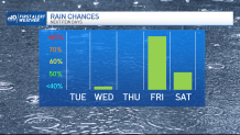
There’s some leftover warmth on Wednesday, but with a subtle frontal passage, the numbers don’t look as warm. In fact, there’s a small chance we may even see an early shower with that front passing. The day starts mild, so we’re comfortable forecasting the highs to reach the low/mid-60s once again.
Get Boston local news, weather forecasts, lifestyle and entertainment stories to your inbox. Sign up for NBC Boston’s newsletters.
Veterans Day sees the numbers slump back to near normal, although with an advancing warm front late day, we’re bound to see the clouds thicken. Wind will pick up too as a vigorous storm moves in from the Plains.
This storm isn’t tracking near us like our big pre-Halloween nor’easter (which, if you’re keeping track, is moving closer to Ireland now). Instead we are caught in the broad wind field that is circulating around the very large storm.
This translates to a gusty wind, but not a lot of damaging wind. Peak wind speeds could reach 45-50 mph on the Cape/Islands at the height of the storm late Friday, but generally the gusts will be 30-40 areawide. Rain will wash out the Friday forecast too, with the potential for over 1” of water from the storm.
More on that as we close out the week. In the meantime, take in some rays and mild temps.