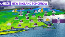
Even though a weak cold front has dropped temperatures in New England after a cozy day Tuesday, our highs still remain above average Wednesday.
Temperatures are rising to the upper 50s and low 60s around New England.
We started off the day with some showers in the north that have been advancing east, and fortunately clearing out our skies, allowing for a slight warm-up and dry afternoon.
Get Boston local news, weather forecasts, lifestyle and entertainment stories to your inbox. Sign up for NBC Boston’s newsletters.
Don’t let this fool you -- our lows are dropping considerably again and will make it to the upper 20s north, 30s south Wednesday night, letting some frost form again as we wake up. Don’t forget your ice scraper if you head out before sunrise.
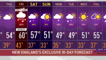
While Thursday is expected to remain dry, our highs will be lower than Wednesday's. We’ll be staying in the 50s throughout New England and have more cloud coverage building in after midday.
Friday is the day we’ll see some more showers, and this time they will be more widespread. We have a First Alert for Friday as wind and rain will move through New England, allowing for gusts of up to 50 mph in the Cape and over 30 mph inland.
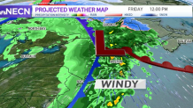
At this moment this low pressure is still building strength. It’s producing storms over northern Texas, Oklahoma and Kansas while moving east, and we’ll see snow in the Midwest. This system will be dropping temperatures significantly over the country, all the way through the southern states.
While we won’t be watching as significant of a drop, we’ll see showers moving across New England along with thunder and strong wind gusts. Our highs will drop into the mid 50s by Saturday and down to upper 40s and 50 by Sunday. Our total rainfall amounts are expected to remain between 1 and 1.5 inches by the end of Friday.
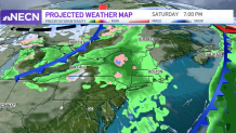
Even though Saturday is expected to remain mostly dry, showers may move in during the evening hours and linger on through early Sunday in the northern states. It is likely that most of the south will be enjoying a generally dry Sunday.
Next week will be a generally cold one as we’ll start the week with highs in the upper 40s and lows that will reach 30s in the south, 20s inland and possibly watch some teens in northern Vermont, New Hampshire and Maine.