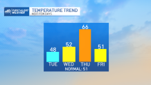
Storms take a backseat as we watch the thermometer go haywire this week. We’ve plunged into the cold abyss this morning, with only a small recovery this afternoon amidst a chilly breeze. Today will feature the coldest temperatures of the week, before we face the warmup on Thursday.
That puts Wednesday squarely in the “transition day” space. A warm front will be lifting through, but it will be too late to realize the milder temps.
It does, however, mean that the warmer temps will slowly trickle in over the course of the evening and night. Temps will act a little strange Wednesday evening as they bottom out in 30s and 40s, then rise through the night and into Thursday morning.
Get Boston local news, weather forecasts, lifestyle and entertainment stories to your inbox. Sign up for NBC Boston’s newsletters.
Then we’ll be ripe for a 60s takeover for the afternoon. Southwest winds coupled with abundant sun will boost us to the upper range of the 60s and maybe even near 70. This warmth is short-lived, however, as a sharp cold front will be approaching by evening.
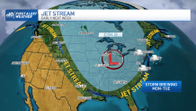
That’s certain to sink our temps for the end of the week and the weekend, and coincides with a bigger pattern change that could set the table for a storm on Monday and Tuesday. Details are scant, but the models are certainly keying in on something off the New England coast in that time frame.
In the meantime, enjoy the wild ride.