


From the NBC10 Boston First Alert Weather Center… Today (Thursday): AM mixed showers, midday mild breeze, late day rain showers. Highs in the 50s. Overnight Thursday Night: Showers depart for clearing, mountain snow showers. Lows in the 30s, wind chill 20s. Friday: Blustery with sun. Highs near 40, wind chill 30. Cape Cod Radio Forecast: Today (Thursday): AM showers, then a mild south wind gusting to 30 mph, passing evening showers. Highs in the middle to upper 50s. Overnight Thursday Night: Showers depart for clearing. Lows around 40, wind chill 30. Friday: Blustery with sun and a west wind gusting to 35 mph. Highs near 45, wind chill 30s.
We’ve had some developments over the last 24 hours that are putting the idea of a cold, snowy start to winter "on ice."
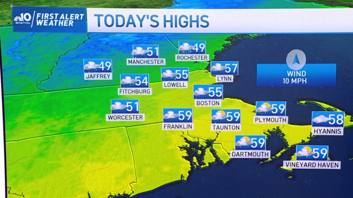
Let’s start with today’s forecast: Balmy and windy.
Showers depart this morning, with a break for several hours – in addition to some breaks of sun. It’s in this window of time that we’ll see the temps make their run at 60. A couple of towns may make it, but many of us hover in the upper 50s through the afternoon. Not too bad for the second day of meteorological winter. The follow-up cold front still looks charged for some squally-type rain after dark, and a solid batch of cold air will funnel in on more gusty winds.
We’re following up this storm with a couple of days of below average temperatures through the weekend. We could even see some "festive flakes" (I don’t know why that term rubs me the wrong way) on Saturday as a weak weather system zips through.
Get Boston local news, weather forecasts, lifestyle and entertainment stories to your inbox. Sign up for NBC Boston’s newsletters.
It’s the second (and possibly third) storm in the pipeline that makes me think we’re going to have to wait for any hint at extended cold and snow. Yesterday it looked like we had a chance (insert Lloyd Christmas meme) with a pattern that seemed "just cold enough." Now, it appears that the jet stream has shifted much farther north, to the point that as storm systems arrive, the warmth floods New England. This puts us in the position to hit 60 or more on Monday, with temperatures in the 50s again on Wednesday.
We’ll have to wait and see how things play out closer to Christmas, but for the time being, get comfy with a brown landscape.

