
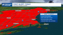
Strong and sometimes severe thunderstorms are expected to crop up across New England starting Monday afternoon, with some areas getting damaging wind, heavy rain and lightning.
See all severe weather alerts in your area here and track live radar below:
Cold fronts in New England usually pass from west to east, but late Sunday night into Monday morning, nature flipped the script with what we call a backdoor cold front that moved from Maine to Massachusetts, from northeast to southwest.
There wasn’t a lot of push to this cold front, so after reaching central and southeast Massachusetts, it put the brakes on, but the job was done: the areas behind the front in northeast New England saw a puff of cool air, dropping temperatures into the 50s, 40s and – in northern Maine – even the 30s.
Get Boston local news, weather forecasts, lifestyle and entertainment stories to your inbox. Sign up for NBC Boston’s newsletters.
For much of the day, Monday’s weather in New England will be governed by the difference in air either side of the stalling frontal boundary: areas to the north of the wind shift line will see a light northeast breeze with cool temperatures and clouds, communities either side of the front in Massachusetts occasional showers (few and far between) and a light wind, far southern New England breaks of sun and warmer temperatures in the 70s.
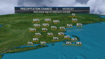
As an energetic disturbance aloft approaches from the west, its corresponding surface low pressure system – the storm center – will initiate a swath of rain, downpours and thunder out of upstate New York that will move west into western New England Monday afternoon and Eastern New England Monday night.
Weather Stories


Coupled with the clash of warm and cool air already set up in New England, this slug of rain will produce a quick one to two inches of rain in central, northern and western New England, with smaller amounts to the southeast – likely under half an inch in Southeast Massachusetts.
Nonetheless, the combination of upper atmospheric energy and a big temperature difference at ground level will mean favorable conditions for thunderstorm development, and a few storms will have the capacity to produce isolated damaging wind gusts as severe thunderstorms. The time of greatest impact will be from 4 p.m. to 11 p.m., northwest to southeast.
Although partial clearing may follow the end of the rain overnight Monday night, areas of inland fog will develop and a continued presence of energy aloft will mean lots of clouds Tuesday, with renewed scattered showers blossoming, particularly from midday onward until evening as high temperatures stay locked in the 60s under the abundant cloud cover.
By Wednesday, clouds will likely still be stubborn but showers will be quite limited, if they develop at all, for what looks right now to be a mostly dry day with highs rebounding a bit into the 70s.
In an active weather pattern, with the storm-steering jet stream winds flowing directly over New England, another disturbance arrives Thursday with yet another slug of rain and possible thunder expected, but this time the cold front associated with the fast-moving storm center sweeps drier and cool air into New England from Friday into the weekend, knocking high temperatures to either side of 60 degrees Friday for many and in the 40s for some of the North Country, including Friday night lows in the 30s for many!
A recovery is expected over the weekend, with temperatures returning to seasonable levels headed into next week in our exclusive First Alert 10-day forecast.
