We have more waves of clouds, flurries, and cooling temperatures as we continue the week.
An upper-level disturbance continues to carry in clouds and a few flurries Tuesday evening. With another wave possible near the south coast tomorrow morning, that may bring some light coatings of accumulation with any snow shower interacting with the Atlantic moisture at the coast (Rhode Island, Connecticut and Massachusetts).
Most of us will be quiet and mostly clear overnight with lows in the single digits north, teens to 20s south.
A few flurries stick around for Wednesday with highs a tad cooler in the mid-30s and 20s north. The wind picks up a bit too, creating a wind chill in the teens to 20s all day long.
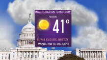
Meanwhile, in Washington D.C. we have great weather for Inauguration Day. Temperatures will be around 40 at noon with sunshine and a breeze, so it's cold but dry. It will be unlike 1961 for Kennedy's Inauguration where the metro area had heavy snow in the afternoon (8 inches) and a traffic jam with cars stranded after the ceremonies.
Thursday brings another wave of flurries and snow showers in the mountains. Ski areas may pick up 1-3 inches of snow thanks to this quick system. Mostly cloudy skies rule elsewhere and highs will again be in the 20s to 30s.
Friday we have a quick break from the cold with highs near 40. But colder air rushes in again for the weekend with highs around 28 Saturday and Sunday.
Our next chance for any measurable snow in southern New England is Monday night into Tuesday. Forecast models are starting to trend farther offshore with this storm, so every outcome is still on the table. We will watch this closely.