
Our ocean-effect snow showers took the lead Friday morning through the afternoon, accumulating over 4" of snow in Plymouth, 2" in Marshfield and over 3" in Kingston, Mass.
Snow Showers Possible Along the Mass. Coast
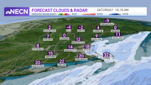
The ocean-effect snow is promising to return Saturday morning reducing visibilities and bringing from light to moderate snow from Cape Ann into Cape Cod and nearby towns.
Our temperatures will remain in the 20s south Saturday, with a north and northeast flow, and lower wind speeds inland that will help keep our highs feeling "less cold."
Get Boston local news, weather forecasts, lifestyle and entertainment stories to your inbox. Sign up for NBC Boston’s newsletters.

If you’re looking for outdoor activities, we’ll be enjoying a mostly dry weekend overall (except for that ocean-effect snow near the shorelines). The sun will be peeking Saturday and while we’ll see more clouds on Sunday, our highs will reach the 30s south, upper 20s north and we’ll be mostly rain and snow-free.
Weather Stories


Snow Flurries in Northern New England
Some isolated snow flurries may pop up in the northern states of Vermont towards Maine ahead of a frontal system pushing in that night into Monday. This means our highs will once again remain below average with highs in the 20s along mostly sunny skies and a new chance to have some snow and showers rolling into Vermont, New Hampshire and Maine by Tuesday morning with the chance of rain/wintry mix on Tuesday afternoon in the south, while temperatures will increase to the upper 30s (expected to be the warmest day of the week).
While overall next week doesn’t appear to be too busy regarding huge snowstorms, our highs will remain wintry in the 20s and 30s range and chances for precipitation will be popping back up on Wednesday and next weekend.
