
It’s a bit chilly out there today! Sure, in the scheme of things, it’s not too terrible, but this December has been mild, so days like today can feel a little extra cold.
The breeze, though not unusually strong, will make it feel about 5-10 degrees colder. Wind chill values will be running in the 20s for many of us this afternoon. Actual temperatures will drop back into the teens and 20s overnight.
Winter begins officially Tuesday with the solstice at 10:59 a.m. It won't be as chilly as today, with a subsiding wind. Temperatures will rebound decently into the 30s and 40s (north to south) for our Tuesday under a mix of sun and clouds.
A coastal storm and disturbance to our north will both arrive to the region overnight Tuesday into Wednesday morning, bringing a mixed bag of precipitation to New England. It’ll be cold enough that some snow will fly in the far North Country, and central/northern Maine – on the order of a few inches.
Get Boston local news, weather forecasts, lifestyle and entertainment stories to your inbox. Sign up for NBC Boston’s newsletters.
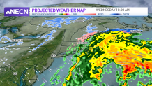
Southern New England will see a period of rain Wednesday morning tapering to showers by the afternoon with clearing to follow by evening.
The morning will be cold enough north and west of Boston to support a little bit of sleet or light freezing rain though, which could create some slippery travel during the Wednesday morning commute so use caution.
High pressure will build in temporarily behind this disturbance, keeping us fair and dry Thursday into most of Friday. No big storms are in the forecast throughout the extended period, though some light rain and snow showers are possible on Christmas Day.
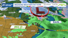
Next week will feature cool temperatures and a fairly quiet pattern with minimal chances for showers.
