It’s a fairly tranquil day to kick off the work week. After a cool start Monday morning, our temperatures are rebounding and we’ll see highs top out in the middle 70s in southern New England and the 60s farther north Monday afternoon. Expect varying amounts of sun and clouds with developing showers in the far North Country.
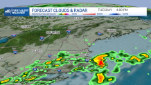
These showers represent the leading edge of cooler air – air that will move into the region Tuesday and usher in a pattern shift for the remainder of the 10-day forecast. I’d have the umbrella with you on Tuesday in southern New England as these showers, occasional downpours and perhaps even an isolated rumble of thunder slide through.

Wednesday’s highs will only be in the 60s under partly cloudy skies. Another chance of some wet weather returns on Thursday with pop-up showers before a ridge of high pressure builds in to end the week.
Get Boston local news, weather forecasts, lifestyle and entertainment stories to your inbox. Sign up for NBC Boston’s newsletters.
That’s setting us up for a classic fall weekend ahead – mainly dry conditions, cool mornings and highs in the 60s – perfect for outdoor plans, sports and fall fairs!
Meanwhile, the tropics are still active and we’re keeping our eye on multiple areas of potential development.
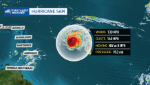
Hurricane Sam is a powerful Category 4 storm, and will remain a “major” hurricane for several days as it sits out over the Atlantic, currently several hundred miles east-southeast of the northern Leeward Islands. Sam will eventually take a turn to the north and likely pass east of Bermuda this weekend.


