A beautiful winter day is in the cards for New England on Sunday with high pressure the main weather feature across the Northeast.
Expect plenty of sunshine and high temperatures in the 30s for most, though a wind generally 5-10 mph will make it feel like its right around 30 at the warmest time of the day.
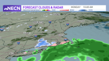
Clouds will increase Sunday night ahead of a disturbance that will pass well to our south tomorrow. Some upper level energy will come close enough to bring the chance of some scattered rain and snow showers to the south coast Monday morning to early afternoon, with a the chance of a coating of snow on grassy surfaces in a few communities, mainly in southwest Connecticut Monday morning.
Get Boston local news, weather forecasts, lifestyle and entertainment stories to your inbox. Sign up for NBC Boston’s newsletters.
Highs will be in the 30s and 40s from north to south. Tuesday and Wednesday features generally quiet weather aside from some northern New England snow showers that will drop an inch or two through Wednesday evening.
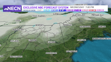
By the end of the week, we turn our attention to low pressure coming out of the Ohio Valley. A stationary boundary out ahead of it will serve as the trigger for a burst of snow Wednesday night into Thursday, likely with a rain/snow line in southern New England.
Roads may be sloppy with difficult travel Thursday morning, lingering into Friday as the storm center itself crosses eastern Massachusetts. A track like that would mean areas of snow through the interior into northern New England on the order of 6-12” (potentially more north) on Friday and a mostly rain event farther south and east.
Some showers may linger into the start of next weekend, before brighter, drier conditions move in. We’ll keep you posted on the storminess to end the week in the days to come.