
Much more comfortable air has been pushing into the region and our dewpoints will continue to drop this evening and tonight. That means you can open up the windows and let the fresh air in!
Temperatures will fall into the 50s and 60s overnight with some patchy fog developing in the typical spots courtesy of clear skies and a light wind. Tomorrow, high pressure is the main weather feature on the map, though a little upper level energy may allow for a few sprinkles to develop here and there. Otherwise, our temperatures will be slightly cooler than average for this time of year, running in the 70s to lower 80s.
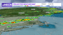
Friday our next disturbance approaches, bringing the threat for some scattered showers in the morning followed by a round of late-day thunderstorms. It’s a little uncertain right now how widespread or organized these storms will be, so for now, hold off on canceling outdoor plans and events and instead, just have a backup plan to duck inside if necessary.
Get Boston local news, weather forecasts, lifestyle and entertainment stories to your inbox. Sign up for NBC Boston’s newsletters.
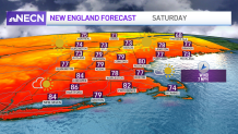
After that, our weekend looks simply splendid. Sunshine, low humidity and highs 75 to 80 will be a treat on both Saturday and Sunday. Next week we turn warmer, running 85 to 90 many days (local sea breeze potential to keep the shore a little cooler) with pop-up thunderstorm action, particularly during the middle and end of the week. Our exclusive 10-day forecast now includes the start of next weekend, which looks nice!
