
Temperatures once again today were nice and pleasant with very low humidity levels. The pollen count has been very high, the brush fire risk has been high again, and some brief relief is on the way for tomorrow as showers roll through.
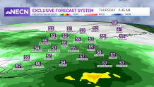
Downpours possible Thursday
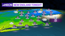
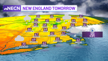
Tonight’s lows drop to the 30s in the north country, 40s to low 50s south. It’s another comfy night where the AC gets a needed break. Highs will be stuck in the 50s to 60s tomorrow as the rain moves through along a warm front. A couple of downpours will be around during the morning commute. Then by afternoon, western New England slowly dries up, while the scattered showers head out of Boston around dinnertime. Northern New England will continue to see some downpours through midnight as the last bit of rain heads out of Maine overnight.
Get Boston local news, weather forecasts, lifestyle and entertainment stories to your inbox. Sign up for NBC Boston’s newsletters.
Things heat up again for the weekend
Weather Stories


A big warm up is on the way for this weekend, so break out the beach gear! Friday is a transition day as we see slightly higher humidity levels and temps in the 80s south, 70s at the coast and in Maine. It will be a mostly sunny day, and still comfy enough to get some yard work done before the triple “H” weather takes over. Both Saturday and Sunday will be hazy, hot, and humid with highs in the low to mid 90s. Combined with the humidity our heat index could be 95-100.
Thunderstorms possible Sunday
A cold front approaches on Sunday with scattered showers and thunderstorms in the afternoon to evening. Even on Saturday, some popup storms are possible in the mountains. The storms roll through Sunday night into Monday along that cold front, with temps cooling to around 70 for the start of next week.
