We have a beautiful day in store today and high pressure reestablishes itself over the northeast. Highs will rise into the mid and upper 60s, and 50s at the shoreline thanks to a light east, southeast breeze.
The thin clouds may be a bit stubborn to clear out completely, but at least it is much warmer than yesterday. Clouds increase tonight and some scattered rain moves across western and northern New England as lows drop to the upper 30s and 40s north, mid 40s south.
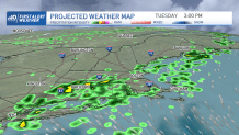
Tuesday brings us scattered rain showers as a cold front moves through. Northern New England will see the rain in the morning first, with showers in southern New England by afternoon. By evening a low pressure system develops south of New England and enhances our rain chance overnight into Wednesday morning.
Get updates on what's happening in Boston to your inbox. Sign up for our News Headlines newsletter.
Get Boston local news, weather forecasts, lifestyle and entertainment stories to your inbox. Sign up for NBC Boston’s newsletters.
This low doesn’t completely move out, so we continue to see a cool, showery weather pattern through midweek and perhaps into the end of the week. Snow showers are also possible across the mountains for Thursday into Friday.
Highs stay in the 50s through the rest of the week thanks to the unsettled pattern. We finally shake this cool pattern for the weekend with slightly warmer temps by Sunday.