
Summer warmth is on the way to New England this week.
A cold and breezy start
First we continue the start of the week with a couple of cold nights and cool days, then a warm up for all by midweek. A strong coastal storm is spinning off the Carolinas and this northeasterly airflow is influencing the southern and eastern parts of New England for a couple more days. That’s why it has been so windy too, as we are stuck between a strong high pressure center to the north and that low south. There’s plenty of sun again Tuesday, but just like today we have a continued gusty northeast wind and a cool marine influence over the next few days.
Get Boston local news, weather forecasts, lifestyle and entertainment stories to your inbox. Sign up for NBC Boston’s newsletters.
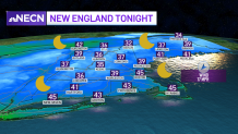
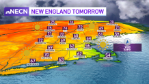
Lows tonight dip into the low 30s north to 30s and low 40s south under a clear sky and northeast breeze. Highs tomorrow and Wednesday will again be in the 50s at the coast and the 60s to near 70 inland. Some low clouds and drizzle may develop at the coast Tuesday night into Wednesday.
Away from the coast and farther northwest is where the temps slowly build and that’s where a warmup is already underway. With the gusty wind, low humidity and dry weather we have a couple more days of a high wildfire or brush fire risk and also a very high pollen count from all the tree pollen.
We could reach 80-degree temps by Thursday
Weather Stories


Thursday and Friday our northeast influence breaks down a bit and we all enjoy highs in the 70s to low 80s. Sea breezes at the coast will keep those spots cooler from time to time. The warm temps are here to stay through the weekend, with even some thunderstorm chances. Stay tuned!
