Chilly temperatures are found all over the northeast again, making it a frosty morning for some. We have lows in the 30s far north and in the 40s farther south.
Some patchy fog has settled in the valleys, reducing visibility. But that fog evaporates as the sun climbs higher in the sky.
It’s another day to dress in layers because by this afternoon, our highs reach the 60s with mostly sunny skies. An upper-level low continues to spin up some clouds and daytime heating may trigger sprinkles or showers, especially across Maine.
More cool temperatures are forecast tonight with another warm afternoon Saturday under full sunshine. Northern New England will see a weak system approaching from the west that may bring in scattered rain.
Get Boston local news, weather forecasts, lifestyle and entertainment stories to your inbox. Sign up for NBC Boston’s newsletters.
Meanwhile, Hurricane Sam makes its closest pass to us way offshore. Wave heights may reach three to six feet with a high rip current risk.
Sunday we see our pattern shift a bit with a system slowly heading into western New England for the second half of the day. Highs reach the 50s north, 60s to low 70s far south.
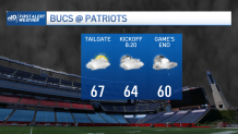
The showers should hold off until after the big Patriots game in Foxboro. Then the rain picks up across the northeast Sunday night into Monday and linger into Tuesday. We may pick up around 1” of rainfall through the first part of the week.