Our so beloved high pressure is moving off the coast Wednesday, and while that’s increasing our cloud coverage, our temperatures have also decreased, making it the coolest day of the week so far.
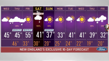
Our highs, however, are still close to 3 degrees above normal. The average for Boston, for example, is 42, while we’re reaching 45 on Wednesday afternoon.
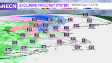
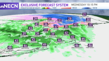
A warm up is on our doorstep, and so is the rain. We’ll be watching showers across northern New England on Wednesday evening advancing into the east through the night and into Thursday. If your commute is after 7 a.m. Thursday, you’ll likely be driving under rain free conditions by then in western New England. Areas to the north will watch lingering showers, but those will move out in the afternoon.
Along with that we’ll watch gradual breaking in the clouds, which will allow for temperatures in the upper 50s and 60s. Depending on how much sunshine we get will determine how much we climb up in our highs.
Get Boston local news, weather forecasts, lifestyle and entertainment stories to your inbox. Sign up for NBC Boston’s newsletters.
Breezy weather will take over Thursday as well, but Friday should be bringing colder weather into the weekend, with some rain and snow in the forecast on Saturday. A cold front will set the stage for accumulating snow in the higher elevations and possible snowflakes trying to peek into northern Massachusetts on Saturday.
Local
In-depth news coverage of the Greater Boston Area.


Because of the unfavorable travel conditions up north, we have issued a First Alert for Saturday.
After that, cooler temperatures follow for Sunday into much of next week, with a trend that will keep our highs mostly below average. A mix of sun and possible flurries could come in for next Tuesday, with precipitation chances returning by the end of the work week.
Stay tuned on all of our platforms and join us on NBC10 Boston and NECN for all the latest updates and further details.