
It’s been a milder day, although our wind speeds have made it feel like 30 degrees after reaching 40 in the thermometer.
Tonight we’ll remain with the upper 30s from Vermont to Maine and into the low 40s for eastern Massachusetts and the south. While tomorrow will be warmer and we’ll reach 60 degrees, we’ll be having showers and strong winds filling in through the evening into Friday morning.
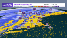
Damaging winds with 70 mph gusts possible
The strongest wind gusts are expected Thursday after 10 p.m., 50-60 mph in the southeast. We wouldn’t be surprised to see Nantucket or the Cape even reach 70 mph. Isolated spots across New Hampshire may also watch over 60 mph as well as central and western Massachusetts. Our biggest concern will be in the south and southeast where the highest wind speeds are projected to be.
Get Boston local news, weather forecasts, lifestyle and entertainment stories to your inbox. Sign up for NBC Boston’s newsletters.
Rain and snow melting could cause street flooding
Rainfall totals may add up to 1” in the most affected spots. Vermont already has a Flood Watch that will go into effect Thursday afternoon into Friday, watching the potential for excessive runoff due to the combination of snow melting and moderate rainfall that may cause sharp rises and ice jamming in the drains.
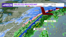
Because of this, your morning commute on Friday may be impacted if streets on your usual ride to work suffer from poor drainage. Otherwise, Friday afternoon will be dry and less windy, but temperatures will start off mild then experience a noticeable drop in temperatures as the day goes by - courtesy of a cold front pushing south.
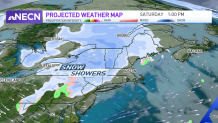
Saturday morning will be cool and dry with possible snow moving in Saturday afternoon to the mountains, then we’ll watch that come down to the south but likely turning ingo a wintry mix as it encounters higher temperatures. It’s still early to call it but for now it’s best to keep it as a possible scenario. Our Sunday will be dry with temperatures remaining in the upper 30s. Monday rises to the upper 50s with a high pressure system locked in, while it shifts east, our precipitation chances creep in and remain from Tuesday to the end of the week.
