
Dangerous heat is expected today with record-breaking temperatures and high humidity.
Heat advisory remains in effect until 8pm tonight, possibly extending through tomorrow. Isolated showers and storms across the interior are expected as well this afternoon.

The heat peaks today with oppressive heat and humidity across our region. Temperatures for most will be in the 90s with some hitting 100 in the CT and Merrimack Valleys. Humidity is a big player today, triggering heat indices up to 104. Overnight tonight, not much relief with increasing dew points. Temperatures in the mid to upper 70s.
Get Boston local news, weather forecasts, lifestyle and entertainment stories to your inbox. Sign up for NBC Boston’s newsletters.
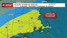
As we head into the workweek, we start off Monday with showers and strong to severe thunderstorms. The main threats with these storms are strong winds and locally heavy downpours. Temperatures will be around 90.

Finally, the heatwave ends this Tuesday and Wednesday, with gorgeous weather and seasonable temperatures. To top it off, lower humidity will return as well. By Thursday, the weather will be warmer and more humid with another chance for showers and storms ahead of another cold front.
Weather Stories


Stay safe, cool and hydrated.
