
Are you doing something outside this afternoon? I hope so! Just be mindful of the high rip current risk at our beaches from leftover surf courtesy of what was once Tropical Storm Odette.
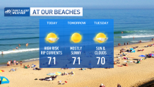
Otherwise, we have a beautiful stretch of September days ahead of us; lots of sun, low humidity and highs in the low 70s. Expect clear, calm and cool conditions tonight with lows dropping into the 40s and 50s from north to south. Tuesday won’t be as bright with clouds mixing in with the sun. I can’t rule out a few spotty showers through the interior on Wednesday ahead of a slow moving cold front.
This front will bring more numerous showers transitioning to downpours with embedded thunder on Thursday. There are signs this disturbance will slow down as it exits, meaning some rain may linger into Friday morning. We’ll keep you posted on the timing. For now, we’ll keep next weekend (first weekend of Fall!) mainly dry with seasonable temperatures in the low 70s.
Get Boston local news, weather forecasts, lifestyle and entertainment stories to your inbox. Sign up for NBC Boston’s newsletters.
Meanwhile, it’s been an active tropical season thus far, and we now have our 16th named storm: Peter. Tropical Storm Peter is sitting east of the northern Leeward Islands and is forecast to strengthen a bit over the next couple of days, but stay below Hurricane thresholds. It looks like Peter takes a northward turn towards the middle of the week and stays safely out in the Atlantic.
