What a change in air for New England!
Tuesday’s late thunderstorms delivered heavy rain, lightning and lots of hail to spots like northern Massachusetts and southern New Hampshire that don’t often see much in the way of hailstones. Those same storms ushered in a northwest wind that has dried the air.
Not only can New Englanders feel the change to dry air as a drop in humidity, but we can see it, too, with sunshine, mixing only occasionally with clouds.
Northern Maine is a bit closer to the departing disturbance that created our recent unsettled weather. The crown of Maine will see building clouds with some scattered showers Wednesday.
Get Boston local news, weather forecasts, lifestyle and entertainment stories to your inbox. Sign up for NBC Boston’s newsletters.
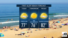
Otherwise, the prevailing northwest wind should be just enough to hold off a sea breeze. But beachgoers should beware of a weak rip current owing to the small swell still reaching the coast from yesterday’s passage of Tropical Storm Bill to our southeast.
Dry air cools effectively at night if the wind is light and sky is clear. With both of those conditions expected Wednesday night, widespread low temperatures in the 40s are predicted, with some 30s probable in deeper valleys of the North Country.
Nonetheless, a cool night will be offset by plenty of sun again Thursday, sending temperatures soaring back to the upper 70s to near 80. Though with a lighter prevailing wind, it’s more likely sea breezes develop in the second half of the day, cooling our beaches from midday highs.
As the sprawling center of high pressure – fair weather – drifts over the Eastern Seaboard and offshore Friday, our wind here at home will shift in the clockwise swirl of air around the high pressure dome. This will shift the wind to blow from the west and southwest Friday into Saturday.
The change in wind direction opens a flow of warmer summer air from the nation’s midsection into New England. Temperatures Friday afternoon will be in the 80s, and Saturday 85 to 90, at least in southern New England. With building humidity comes increasing chances for showers and thunder, possible in the morning but more likely and more focused late day and evening ahead of an incoming cold front.
Saturday’s late storms will be long gone by Father’s Day Sunday, when great weather is anticipated with a renewed shot of lower humidity but still a warm, summery afternoon feeling.
Humidity may build once again early next week with another chance of afternoon showers and thunder building in our exclusive First Alert 10-day forecast, but as that humidity is swept away by likely Tuesday storms, the middle and end of week looks right now like some great summer weather returns.