
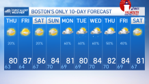
The bulk of the action from Wednesday’s low stayed around northern New England and coastal Maine. The day and evening were salvageable elsewhere. Northerly coastal winds will change direction Thursday, with the departure of the low. While still gusty at times, westerly flow brings in drier air and a comfortable next few days. Thursday features highs in the upper 70s to low 80s. Drier air closes out the work week too as temperatures soar into the upper 80s, near 90 degrees.
Dry is the status quo, but isn’t good. A new drought monitor will be released Thursday, and things shouldn’t change much for southern New England. It’s likely a few areas of Maine and New Hampshire see improvement with recent rains.
Mostly sunny skies carry into Friday and Saturday. Another disturbance drifts south of Long Island and may bring a few evening to overnight sprinkles on Saturday night. But I don’t anticipate much fanfare.
Get Boston local news, weather forecasts, lifestyle and entertainment stories to your inbox. Sign up for NBC Boston’s newsletters.
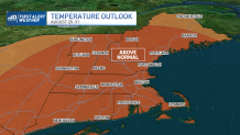
A few opportunities for rain arrives in the 10-day forecast, but more attention shifts toward above average warmth to close out August. While not every day, the trend is that the average of days between Aug. 25 -31.
