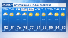
Fresh new air is moving into the region today as a cold front continues to exit the south coast of New England. Behind it, the humidity has been dropping and clouds have been on the decrease, and that trend will continue through the remainder of the afternoon.
A few showers will linger into the afternoon on Cape Cod. otherwise we’ll be drying out. High pressure will build overhead tonight, allowing for nearly calm winds and clear skies – a very comfy night for sleeping.
Tomorrow won’t be quite as warm, thanks to a southeast wind. Highs will top out in the 70s at the coast to low 80s inland -- slightly below average for this time of year. Morning sunshine will also be replaced by building clouds, perhaps yielding a sprinkle or two, though the majority of us will be dry.
Get Boston local news, weather forecasts, lifestyle and entertainment stories to your inbox. Sign up for NBC Boston’s newsletters.
Our next disturbance moves through on Friday, bringing some passing showers to dodge, and a round of hit or miss thunderstorms late in the day. After that, an amazing stretch of weather moves in for the upcoming weekend.
We'll have mostly sunny skies, warm temperatures and low humidity on BOTH Saturday and Sunday. Soak it up!
Next week features some classic summer weather with highs in the 80s and a chance of thunderstorms, mainly on Tuesday and again Thursday as seen in our exclusive 10-day forecast.