Some middle and high altitude clouds are dimming the sunshine at times Monday afternoon, but I don’t think that takes away from the fact that it’s a beautiful day regionwide. Low humidity and highs in the 70s to lower 80s? I’ll take it.
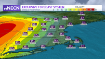
Tuesday will be a similar day, though I do anticipate more in the way of cloud cover. Late in the day Tuesday, there’s a risk of a shower or thunderstorm in far western New England -- otherwise, expect another dry day for many of us.
Wednesday brings change. Cloudy skies and increasing dewpoints means a return to sticky conditions across the area. With the humidity also comes an increased risk of showers and storms, although at this point, it looks like hit or miss action.
Get Boston local news, weather forecasts, lifestyle and entertainment stories to your inbox. Sign up for NBC Boston’s newsletters.
By Thursday though, remnant moisture from what is currently Tropical Storm Fred making landfall in the Florida Panhandle will travel in our direction. Tropically infused downpours will result as this energy comes overhead in New England, and may cause some localized pockets of flooding in the southern part of the region.
We stay unsettled on Friday as well, with numerous showers, downpours and storms around. A separate tropical system -- currently Tropical Depression Eight, soon to be named “Henri” -- will circulate around Bermuda over the next several days and stay well southeast of us.
That being said, increased surf and rip current risk will have to be monitored at our shoreline and coastal waters by Friday and Saturday.
The weekend will feature partly sunny skies and a few showers and storms, with highs in the 80s. Looks like we stay either side of 80 through the beginning of next week, before above-normal temperatures try to return.