The early clouds continue to give way to some sunshine this afternoon as high pressure settles in. We stay quiet and dry through Tuesday, in fact.
Highs today reach the 40s to 50s, even at the coast, thanks to a gusty northwest wind. The wind relaxes overnight with a clear sky and temps fall to the 30s and 20s north.
More sunshine is in the forecast for tomorrow as our highs reach the 40s to 50s again with less wind. Some spots inland reach 60, while at the coast the temps may stay in the upper 40s to low 50s thanks to the afternoon sea breeze.
Sign up for our Breaking newsletter to get the most urgent news stories in your inbox.
Get Boston local news, weather forecasts, lifestyle and entertainment stories to your inbox. Sign up for NBC Boston’s newsletters.
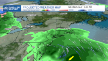
Midweek rain returns for Wednesday into Thursday. The first wave of rain heads through all day Wednesday in southern New England. Northern New England will see lighter shower chances then a wintry mix chance late that night.
Another wave of low pressure moves through all of New England Thursday, into Friday. Late Thursday, we may see a couple thunderstorms around. High terrain in northern New England will see a wintry mix and light snow to then rain, and heavy rain for everywhere else south.
Highs will be cooler in the 40s. After this heavy rain and around 1-3” of rainfall accumulation, our temps warm up a bit late Friday to the 60s. More highs around 60 degrees are anticipated both days this weekend but it won’t be completely dry.
A cool pool of air aloft will keep daytime pop up showers around from time to time. Next week our forecast has the potential for 70 degrees as a large warm up moves in. Stay tuned!