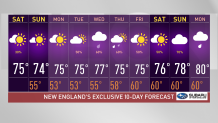
We're wrapping up the work week with below-average highs - another afternoon in the 60s for Boston, 50s for much of Maine and 60s on our coasts. Western Massachusetts and Connecticut have enjoyed the nice warm up along a few breaks in the clouds, with temps rising to the upper 70s. Along with that, showers and storms have popped up over Vermont and New Hampshire. Remember, when thunder roars, go indoors. Showers will continue tonight moving into the east, but fortunately for many, we'll see drier conditions by tomorrow.
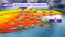
Our skies will clear along western and central New England by lunchtime tomorrow. We'll see a welcomed warm up as well, we're getting ready to see more seasonable highs with temperatures reaching the 70s in Boston as well. The wind will switch direction and bring along a pleasant feel to the air. Dew points will decrease, and with this drier air filling in closer to NH and Maine late afternoon tomorrow, our rain chances will diminish by tomorrow night in those affected areas.
Rain chances decrease even more for Sunday, we see isolated showers popping up only in the far northeast, but the change in temperatures will also be appreciated as now ME will also get to appreciate more sun. The dry trend continues through Monday, when our highs remain in the 70s. We'll then see temperatures take a slight dip along with more cloud coverage on late Tuesday, we'll see showers moving through and rain chances that will linger on through the end of the work week.
Get Boston local news, weather forecasts, lifestyle and entertainment stories to your inbox. Sign up for NBC Boston’s newsletters.