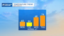
We’re deep into the cool air now. Highs today will struggle to make 60 degrees in many spots – especially in the elevated towns and cities in central Massachusetts and southwestern New Hampshire.
A pool of cool October air is spinning in plenty of clouds too, so there’s not much in the way of brilliant sunshine. As the day progresses, we should see less and less sun as the clouds build up into the chilly air overhead.
Mornings will be chilly too. We may be near frost in some suburbs by tomorrow morning, but I think a lot of the normally cool spots will bottom out in the mid-30s at the coolest. But this cool snap is just for the next two days.
Get Boston local news, weather forecasts, lifestyle and entertainment stories to your inbox. Sign up for NBC Boston’s newsletters.
In typical New England fashion, the turn will be swift and defining. A simple turn of the wind direction on Wednesday will signal the change to milder air. Highs on Thursday and Friday should top 70 degrees again in an airmass that could become a little humid too.
Cooler air will finish the workweek as the temperatures roller coaster continues. This second wave of cold could be more pronounced and stick around a bit longer. We’re eying this one for some real October chill.
Could it actually be time to turn the heat on at home?