
The wintry mess continues to create massive problems on the roads this evening. Even though the heaviest precipitation is moving offshore, the light intermittent showers or sleet showers will still create new slick spots on untreated surfaces.
Temperatures Stay Cold, Wind Chills Near 0
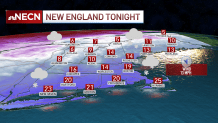
Temperatures continue to fall, teens in the north country, 20s south. Overnight lows drop to the single digits and teens, with wind chills around zero as a breeze sticks around from the northwest.
Get Boston local news, weather forecasts, lifestyle and entertainment stories to your inbox. Sign up for NBC Boston’s newsletters.
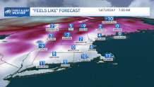
Our weather turns icy cold and quiet for this weekend. Lows drop to the single digits with subzero wind chills as everything freezes in place. Highs reach only the teens and 20s Saturday, but at least it will be nice and sunny. We keep a breeze around from the northwest, adding to the chill. Sunday will be less windy with more sun and highs in the 20s.
Warmer by Next Week
Temperatures next week will slowly become milder as we go to the 30s Monday and Tuesday, then into the 40s for midweek and perhaps through Friday. Minor low pressure systems pass by the northeast to our south and to our north next week, with no real direct hits at this time.
Weather Stories


An ocean storm develops and stays south of us for Monday into Tuesday. On the northwest edge, some mix to snow showers develop as the storm grazes by. Light accumulation is possible. Stay tuned for any updates to the track of this system, since if it heads more north we may see more snow. This is not like the blockbuster nor’easter we had earlier in the week, but it will be a nuisance storm. Another low-pressure system passes north of New England for the end of the week, only to bring scattered snow showers across ski areas.
