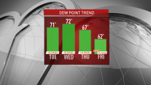
The stifling heat and humidity continue to have a grip on the region, and will stick around for one more day tomorrow before a bit of relief arrives.
After reaching records highs yesterday (tying the old daily record in Boston) – we’ll see the temperatures soar into the 90s again with heat index values up to 104 degrees.
While an isolated thunderstorm can’t be ruled out later today, I’m not expecting too much action on the radar. I think a few may pop this afternoon into early evening, but will tend to fizzle once the sun sets.
Tomorrow, more scattered action is expected, and some storms could become severe, with damaging wind gusts the primary threat. Highs will push 95 to 100 degrees again, marking the 3rd day in a row of 90+ degrees temperatures, meaning the heat wave will be official.
Get Boston local news, weather forecasts, lifestyle and entertainment stories to your inbox. Sign up for NBC Boston’s newsletters.
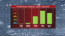
Thursday certainly won’t be as hot, but the humidity will still be high. A front nearby will focus showers and developing downpours, which will drop some heavy rainfall and may result in some localized flooding.
It looks like we’ll stay unsettled on Friday with another round of showers and downpours possible – although the humidity will finally break and you’ll certainly feel the difference.
It’s still too early to say where and perhaps more importantly, what time, there could be some wet weather this weekend, but I’m hopeful for some gradual improvement, especially by the 4th of July. Expect lots of clouds this weekend and cooler than normal temperatures (70s). Next week, we’ll climb back into the 80s.