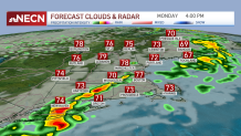
A cold front is heading through New England today so we are gearing up for some soaking rain. A First Alert is issued through this evening with heavy downpours, and some ponding on the roads that will lead to potential delays during the evening commute.
However, most of us welcome this rainfall since we have been so dry lately. The gardens and lawns will see a nice drink as the downpours and a couple thundershowers roll through from afternoon to evening.
About a quarter inch, to 1.25” of rain is possible through tonight. By 4 p.m., most of the heavy rain will be mainly southeast, as northwestern New England dries off. Highs still manage to reach the 70s to 80s with high humidity. Then the humid air retreats south and comfy air returns through midweek.
We dry off across the Cape and islands after midnight as the line of rain heads offshore. Lows tonight drop to the 40s and 50s north, low 60s far south.
Get Boston local news, weather forecasts, lifestyle and entertainment stories to your inbox. Sign up for NBC Boston’s newsletters.
Tuesday is dry, with low humidity and highs in the mid to upper 70s. Higher elevations could see a brief pop up shower late in the afternoon. There is an even lower chance for a pop up shower in the mountains Wednesday. Most of New England stays dry and beautiful!
Get updates on what's happening in Boston to your inbox. Sign up for our News Headlines newsletter.
Highs gradually increase in to the 90s again in time of the holiday weekend. Humidity creeps up by the end of this week and for the weekend it’s muggy.
Saturday is the day we will see scattered thunderstorms along another cold front. Good news is that Sunday and Monday look to be dry and cooler but still around 80! Stay tuned on the rain timing as things could still change a bit.