
This is one of two rainy commutes to affect us this week. Combined with rain on Saturday, this is the wet spell we all were hoping for to put a dent in the drought.
First thing’s first, however. Rain will exit quickly this morning, then sun busts through the clouds. Remarkably, it’s about as warm as yesterday, with highs leaping to the low 80s in spots. This will be a marked turnaround from the rainy, damp start to the day.
We won’t be as lucky tomorrow. Hot on the heels of this storm will be a much larger - and more waterlogged – storm system. This will take up more of our Thursday, set down at least an inch of rain in many spots, and give us a slight chance of strong storms.
Right now that seems to be sequestered across southeast Massachusetts, all the way to the Cape and Islands. It doesn’t appear at this point that there will be much of a problem, but with lots of energy in the jet stream and a well-defined storm system, it wouldn’t take much to get the storms going.
Get Boston local news, weather forecasts, lifestyle and entertainment stories to your inbox. Sign up for NBC Boston’s newsletters.
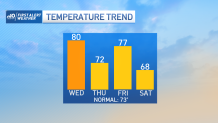
We’ll see a reprieve on Friday, then the next storm takes aim Saturday. This isn’t as well-defined and is favoring the Cape and Islands for steadiest rain and coolest temps.
There’s still hope that some part of the day will be salvageable for some part of the Commonwealth. Add to that a decent looking Sunday forecast, and there’s a bit more hope for the weekend than we were advertising early this week.
