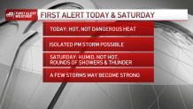
With Independence Day weekend upon us, most New Englanders not only are prepared for heat, but expect it. This year won’t disappoint.
Friday’s high temperatures will be in the middle 90s for some, but it won't reach a dangerous level. There will be limited humidity much of the day, keeping any potential for heat index (elevated “feels like” temperatures) in check. But outdoor plans can certainly be impacted by the heat -- hydration and sunscreen will be two big essentials.
The breeze will increase from the southwest Friday midday and afternoon with the arrival of a weak warm front – the leading edge to increasing humidity. Not only will New Englanders feel the humidity steadily rising during the afternoon and evening, but an isolated thunderstorm or two may develop on the leading edge to that more humid air.
Get Boston local news, weather forecasts, lifestyle and entertainment stories to your inbox. Sign up for NBC Boston’s newsletters.
This will especially impact southern to central New England between 2 p.m. and 6 p.m. Friday evening. Thereafter, clouds will gradually fill in overnight Friday with a muggy and mild night. Showers, downpours and thunder will arrive in scattered form from west to east after midnight toward dawn.
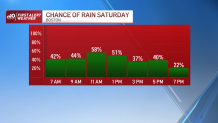
Saturday likely will dawn with at least some pockets of showers, downpours and thunder. While the entirety of the day won’t rain, much of the southern half of New England will see recurring showers, downpours and thunder from time to time from morning until early evening.
Northern New England improves dramatically after lunch Saturday as new, drier air arrives. The leading edge of that new air – a cold front – will trigger the final round of downpours and thunder. It arrives to southern New England from mid-afternoon in southern New Hampshire and northern Massachusetts to early evening at the South Coast.
Get updates on what's happening in Boston to your inbox. Sign up for our News Headlines newsletter.
The passage of the cold front later Saturday opens the door to a brand new air. That will not only lower the risk of showers and thunder substantially for July 3 and 4, but will also provide lots of comfort and terrific weather for fireworks on both nights. Evening temperatures in the 70s and dry weather expected.
Next week features classic early July weather in our exclusive First Alert 10-day forecast. Scattered storms are possible on some afternoons – particularly Tuesday, Friday and Saturday – and high temperatures will be on either side of 80.